"Indulge yourself" was my Mum's parting shot on the phone on Friday evening. What she meant was to use cafes, pubs and *gasp* hotels on my forthcoming tour, rather than my usual co-op and a sheet of nylon style. My issue was a need to visit Mum and Dad, who is back in hospital, and the weather, which was set fine for three days before going down the tubes again. In fact the West of Scotland looked like it was going to be wall to wall sunshine. So Mum's advice was interpreted into letting my mile munching head thoroughly off the leash and blaze through a 5 day route in 2 days, then cycle home.
A couple of short cuts would help, starting with training it to Gourock, then the boat to Dunoon -

The view ahead, still a bit gloomy although there were hints of sun. In fact my day had started in damp, drizzly mist so this was looking much more promising. I departed the boat at Dunoon and hunted out a food source - Morrisons! After a feed on the now much more pleasant sea front (it was looking a bit tired when I was here in 1991) I pedaled off along the shore heading north.

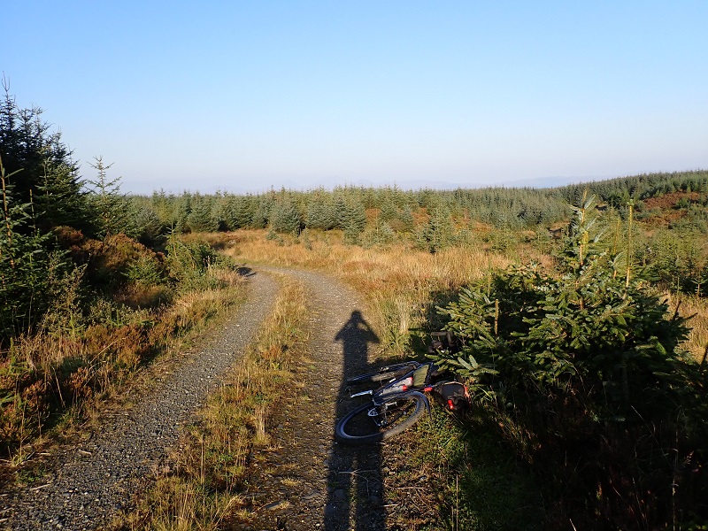
This is Holy Loch, famously used by the yanks as a submarine base in the cold war. When I passed through in 1991 it was a very strange place with lots of (short) submariners wandering around the place and lots of large American automobiles and Harleys in the car parks. They pulled out not long after and left the place to it's own devices. I was pleased to see quite a bit of regeneration of the sea front has been done and it all looks much cheerier. First proper ride on the Stormchaser!

Rather than just cut west over to Tighnabruich, the plan was to throw in a loop up Loch Eck and over the Cowal way. I'd ridden the Loch Eck track in about 1993 and the route over from Glen Branter to Glen Ruel looked a corker. I asked a chap out for a walk for directions to the start of the Loch Eck track as I couldn't make out the line on the GPS. He noted that it might still be closed due to landslips. This rang a vague bell from reading Andy Williamson's trip out here earlier in the year but I figured it would be fine.
Various signs proclaimed 'Road Closed due to landslips and fallen trees' without giving any specifics, which is annoying as what I really wanted was some objective intel on what I would actually be facing. When you have done the BB300, anything is possible. So I ignored the signs and bashed on. As it happened all the fallen trees had all been cleared but two landslip areas remained.

OK, a landslip right enough, but a forwarder had been over them however (and there were lots of tyre tracks) so I carried on regardless. This is not a reason to close a route... Beyond the two slips I was aware of the forwarder tracks and a vehicle track so I figured all would be well thereafter. It was and progress was good up the loch and onto the Cowal Way in Glen Branter.

Only to meet this! The (large) culvert had been totally washed out leaving a 20 foot drop into a rocky gorge. No way was I crossing this but just then an older couple appeared on the far bank. they had done a long loop up the neighbouring glen to that point and were having to back track. Instead I nosed down a path downstream to a crossing point, noting a bloke walking his dog on the far side. Pushing up through the woods was a bit of a struggle thanks to fallen trees and boggy bits (sound familiar?) then disaster struck. The bike struck a tree route and stopped dead, I stumbled and bounced off the aero bar arm rest. Ouch, one very sore rib. Undeterred I got back on track and ground up a huge climb, on near perfect gravel.

The descent was taken with care given my previous incident and the lower bit was a proper farm track which was pretty rough. Backroads took me down the glen to the next bit of hero gravel, after a considerable climb:

A chap in a truck appeared and stated he was about to do some shooting down from the track. I was sticking to the main drag so no worries but the amount of deer that crossed my path suggested he would have easy pickings.
I became aware that this was taking some time and I needed to get the 6.30 boat from Portavadie to get across to Kintyre, or crucially Tarbert and its Co-op, or else starve... I'd started up this track at just after 5 so was a mite concerned when I checked my watch on finally hitting the Otter Ferry road and noting it was 18.10. As usual I had a vague notion there was still a few miles to go but in the event it was nearly all downhill and fast going.


A leisurely ferry trip followed as the sun sank. Tarbert was busy and the chippy shut. There seemed to be some kind of do going on, on the far pier which included a bar and a burger caravan but instead I opted for the Co-op, as per. Food on the (chilly) sea front then off away from the madding crowd and into the peace and tranquility of the woods. I'd thought to do a coastal bivvy but it was actually pretty breezy so woods it was, but a great spot - level, dry and with enough breeze to keep the bugs at bay. A fine evening followed....

Rather than do the coast road I disappeared back into the woods on a fine route which cuts a large corner off and offers more perfect gravel riding. The 'Wild about Argyll' route takes you over the windfarm which is a huge climb on a rough track. This is far nicer.
A nice one, grass growing up the centre!

Rather than do the Knapdale route I'd done before I stuck to the road and then turned off to Ardrishaig on the Sustrans route. This was a mix of nice gravel single track and forest roads, but with some horrible climbs for no gain thrown in....

Finally it dropped me into Ardrishaig and the blessedly flat Crinan Canal towpath. Three work colleagues have been poached to Scottish Canals over the last couple of years and they have all reported the same - no money for maintenance and some big bills outstanding on this canal, which is why it's currently shut for boats....
I chilled on Lochgilphead seafront eyeing up another couple of bikepackers with horribly overloaded bikes - hopefully they weren't doing the WAA route.... Then the Co-op for onward food and off we go. I was aiming for Killin (Co-op), some 85 miles off, so I cracked on. First up was loch Awe after more forest roads. I'd scoped this route out on the map but hadn't quite appreciated the humongous climb up a ridge under the new power lines.

Nice view at least, over Lochgilp and my route so far. The track was a bit of a dog leg but missed out some more road riding. It spat me out on an amusingly decrepit back road complete with grass growing up the middle and cows.
Finally I hit the the Loch Awe road - a long but easy pedal, fortunately without the usual lochside road ups and downs. Annoyingly, the rib had got progressively sorer as the day progressed. It was fine, as long as I didn't breathe too hard!

Ben Cruachan, pump storage scheme dam just visible centre pic. I reached the main road eventually but there was quite a bit of traffic on it, so took a punt on a section of Wades road which according to the map would lop a corner off and dump me into Dalmally direct. Which it did, after a k of vague and over-grown boggy trail. Not gravel-tastic...
Dalmally provided a final coffee and a snack and then off again, up Glen Orchy. I was pleased as I'd had a notion it was getting on a bit but actually only 4pm as I departed Dalmally. I'd also done all of the off road stuff I'd planned and avoided any cop outs. I could have used the main road of course - 20 odd miles to Killin - but it was mobbed with Sunday evening traffic. No thanks. Instead I was on the scenic route, with many trials and tribulations to come!

Yonks ago, there used to be a path up the west side of Glen Orchy promoted as a bike route. The only time I did it, it was already disappearing into the undergrowth and soon after it was forgotten about. Now there is a super smooth forest road that is far nicer to ride on than the actual road and takes you right to the Bridge of Orchy Hotel.
Except it was shut for forestry work. For flips sake this was doing my nut in. Bugger it, it's Sunday evening, no-one will be working. Almost right, they were knocking off and ignored me as they abandoned all the machinery and drove off in various pick up trucks. This is annoying - once upon a time there would just have been signs up warning of forestry work. Now they seem to shut tracks as a matter of course, irrespective of if the works actually impinge upon it, which these didn't, they were just using the track as a timber haul road. The A82 wasn't shut to allow the timber wagons to pass...
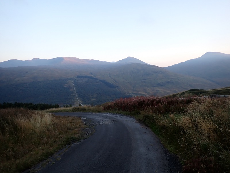
Anyway, enough of all this, onward. To this point there had been a stiff easterly breeze which had helped me along for the most part. However I knew that at some point it would be in my face and I figured Glen Orchy would be the start of it. Except it felt more like a breeze was helping me along. No complaints though! In the photo above you may spot cloud spilling over the hills. As I headed back east, I was expecting to leave the sun behind so seeing this I figured the perma-cloud wasn't far away. But in the event, the blue sky continued.

It's always a bit weird doing this route (WHW from BoO to Auch Farm, then up the Glen to Loch Lyon) when not doing the Highland Trail and I was on a similar mission so riding as quick as the trail (and my rib) allowed. That said I was having a very good time. I knew I would reach Killin in time for the Co-op, the riding was ace and all was well with the world - one of those moments you have to grab and appreciate. Pity about the sore rib! There are famously a few burn crossings on this route, some of which can be a bit deep and pretty rough. The Stormy aced the lot but enough water got splashed up to give me damp shoes. My feet chilled instantly.... Ignoring this I bashed on as I wanted to get over the Pubil climb before it got dark. Again I had feared a horrible headwind along here but it was of little hinderance, in fact the wind had dropped to a mere whisper of a breeze. The dam head was reached eventually and dusk was starting to fall as I ground up what is now quite familiar terrain round the huge potholes. I topped out to see cloud blowing in from the glen and cloud overhead to the east.

Last of the sun, note water pipe which is part of the vast hydro-electric infrastructure that criss-crosses this whole area.
I was a might careful descending the wrecked road to Glen Lochay but the bike fairly flew along the glen road in the last of the light. Overhead was now solid cloud and it was cold but the Killin Co-op was nearly in sight! Better yet there was a chip van!! So I grabbed sausage and chips, a hot chocolate and snacks and beers for later from the Co-op and sat out under the shop awning feeding my face and reflecting on what I'd just done. To crown it all, I knew of a fab bivvy spot just up the cycleway. This is just off the end of the forest track where the tarmac path starts to take you up the last of the climb to Glen Ogle. So it was with a huge grin as I departed Killin in the dark, no sign of anyone on the steady climb up the cycleway. I reached my spot, pitched up and relaxed after 118 miles of top class bike riding, stunning weather and scenery.

As usual I woke to the dawn chorus but nodded off again. I woke a few more times as trucks went by on the nearby A84 and when I eventually decided to get up it was 9am!

Just up the climb you come across this - 30 years after it happened. Me and a mate did a bike ride round here a few days after the crash - the RAF were there collecting all the wreckage - a lot of very small and mangled bits.... When we built the cycleway, the contractor pointed out the actual impact site, all quite sad.

Much greyness in Glen Ogle. I had an expensive breakfast in the Strathyre 'Broch' cafe then tootled home by my standard and oft used route. Total distance 233 miles! My rib is now very sore....
PS - the Stormy was a hoot. 47mm tyres provided just enough bunge to enable easy riding over the rougher bits but flew on the hard stuff (terravail rutlands...) It also handles as sweet as, just a pity I managed to smack a rib on the bloody aero bars!


